- Home
- Billionaires
- Investing Newsletters
- 193CC 1000
- Article Layout 2
- Article Layout 3
- Article Layout 4
- Article Layout 5
- Article Layout 6
- Article Layout 7
- Article Layout 8
- Article Layout 9
- Article Layout 10
- Article Layout 11
- Article Layout 12
- Article Layout 13
- Article Layout 14
- Article Sidebar
- Post Format
- pages
- Archive Layouts
- Post Gallery
- Post Video Background
- Post Review
- Sponsored Post
- Leadership
- Business
- Money
- Small Business
- Innovation
- Shop
Recent Posts
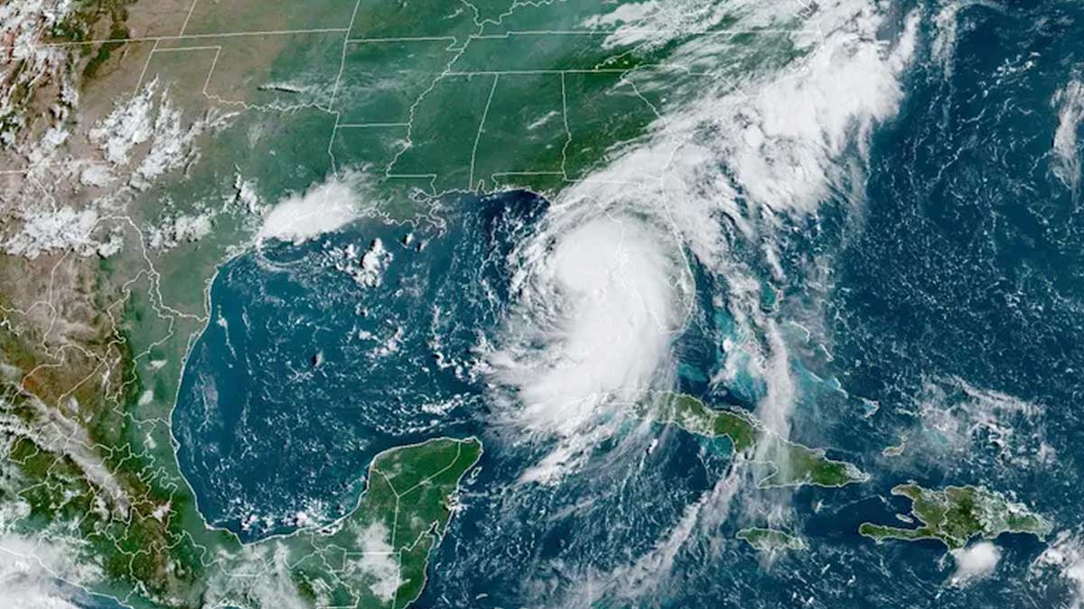
Storm Debby May Become Hurricane Before Hitting Florida

Tropical Storm Debby is approaching Florida and is expected to rapidly intensify into a hurricane before making landfall on Monday. The storm is likely to prompt a state of emergency across much of Florida, marking the fourth named storm of the current hurricane season. Officials are preparing for Debby’s arrival, with significant concerns about potential flooding and storm surge.
According to the National Weather Service (NWS), Debby is projected to make landfall as a hurricane in Florida’s Big Bend region, which includes cities at the end of the panhandle such as Tallahassee, St. Marks, and Apalachicola. The storm is moving northward off Florida’s Gulf Coast. The NWS provided an update on Sunday at 11 a.m. EDT, detailing the latest information on Debby’s trajectory and anticipated impacts.
The NWS has issued warnings of heavy rainfall, forecasting between six to twelve inches in Florida’s Big Bend area and ten to twenty inches in southeast Georgia and South Carolina. These conditions could lead to “catastrophic flooding” through Friday. Additionally, the Gulf Coast of Florida is facing the threat of a “life-threatening storm surge,” with inundation levels expected to range from six to ten feet on Monday.
While hurricane conditions are not expected until Monday, tropical storm conditions, including winds ranging from 39 to 73 miles per hour, are anticipated to begin on Sunday evening and continue through Monday across Florida. These conditions could cause significant damage and disruption.
As of Sunday at 11 a.m., the National Weather Service reported that Tropical Storm Debby had a maximum sustained wind speed of 65 mph. In preparation for the storm, Florida Governor Ron DeSantis declared a state of emergency for much of the state on Thursday. By Friday, the declaration was expanded to include 61 of Florida’s 67 counties. This measure is intended to facilitate a coordinated response to the storm’s impact.
On Saturday, President Joe Biden approved Florida’s emergency declaration and authorized federal assistance to support state, tribal, and local response efforts. This federal aid aims to bolster the state’s capacity to manage the storm’s effects and provide necessary resources for recovery.
The storm’s path remains uncertain, with the National Weather Service highlighting “significant uncertainty” regarding Debby’s trajectory over the next 2-5 days. Current forecasts suggest that the storm’s center may linger over the southeastern U.S., including Georgia and South Carolina, for several days, complicating response planning and preparation.
Meteorologists from the National Oceanic and Atmospheric Administration (NOAA) had predicted this year to be one of the busiest hurricane seasons on record for the Atlantic region. This forecast is influenced by near-record warm sea surface temperatures—often linked to climate change—and the return of La Niña, which reduces wind shear in the Atlantic Ocean and creates conditions favorable for hurricanes. Although the official hurricane season runs from June 1 to November, hurricanes can occur outside this timeframe.
NOAA’s forecast for this year includes between 17 and 25 named storms, significantly exceeding the average of 14 named storms observed annually over the past three decades. This prediction underscores the heightened level of activity expected during the current hurricane season and emphasizes the importance of vigilance and preparedness.
Recent Posts
Categories
- 193 Countries Consortium Partner1
- 193cc Digital Assets2
- 5G1
- Aerospace & Defense48
- AI37
- Arts3
- Banking & Insurance11
- Big Data3
- Billionaires1,497
- Boats & Planes1
- Business332
- Careers13
- Cars & Bikes79
- CEO Network1
- CFO Network17
- CHRO Network1
- CIO Network1
- Cloud10
- CMO Network18
- Commercial Real Estate7
- Consultant1
- Consumer Tech194
- CxO1
- Cybersecurity73
- Dining1
- Diversity, Equity & Inclusion4
- Education7
- Energy8
- Enterprise Tech29
- Events11
- Fintech1
- Food & Drink2
- Franchises1
- Freelance1
- Future Of Work2
- Games149
- GIG1
- Healthcare79
- Hollywood & Entertainment203
- Houses1
- India’s 1000 Richest1
- Innovation46
- Investing2
- Investing Newsletters4
- Leadership65
- Lifestyle11
- Manufacturing1
- Markets20
- Media326
- Mobile phone1
- Money13
- Personal Finance2
- Policy569
- Real Estate1
- Research6
- Retail1
- Retirement1
- Small Business1
- SportsMoney42
- Style & Beauty1
- Success Income1
- Taxes2
- Travel10
- Uncategorized15
- Vices1
- Watches & Jewelry2
- world's billionaires1,467
- Worlds Richest Self-Made Women2
Related Articles
Atos Surpasses 2024 Liquidity Targets with €2.19 Billion Year-End Position, Marking Strong Financial Recovery
French IT giant Atos SE has announced its estimated liquidity position for...
By 193cc Agency CouncilJanuary 22, 2025Innovative Gaming Meets Sustainability: Cranfield School’s “Game of Life” Wins Prestigious FT Teaching Award
In a significant recognition of innovative educational approaches, Cranfield School of Management...
By 193cc Agency CouncilJanuary 22, 2025Bitcoin Shatters Records, Surges Past $109,000 as Trump’s Inauguration Fuels Crypto Rally
In a historic moment for the cryptocurrency market, Bitcoin reached an unprecedented...
By 193cc Agency CouncilJanuary 20, 2025Billions in Child Trust Funds Remain Unclaimed as Young Adults Miss Out on Financial Windfall
A staggering £1.4 billion in Child Trust Funds (CTFs) remains unclaimed, with...
By 193cc Agency CouncilJanuary 20, 2025


Leave a comment